On the eastern border
The village of Vassbygdi extends from the eastern end of the lake of Vassbygdevatnet and then splits into three valleys: Aurlandsdalen, Midjedalen and Stondalen. Of a total of 13 farms, only five are located down by the lake, and as many as five in the valley of Aurlandsdalen. All the farms up in the valleys are so-called high farms. Since time immemorial the village has been just as much oriented towards the east as to the west in terms of contacts and communication. This is due to the fact that the road leading down from the high farms to Aurlandsvangen was long and strenuous. Thus it was often more convenient to cross the mountains to the valley of Hallingdal if you wanted to sell goods from your farms or mountain farms. The shortest road from Aurland to Hol and the Hallingskeid marketplace went by way of Grindsete to Stondalen and further east.
"Hollow rocks"
There is a wide spectre of prehistoric finds in the village of Vassbygdi. One case in point is the find of two graves from the Iron Age on the Veim farm, as well as three so-called hollow rocks. These rocks are located on a rounded hill called Kvaolahaugen, where there is a cleared area 25 metres above an old site. These "bowl-shaped hollows" have been cut into single rocks or bedrock and they turn out to have been made in the Early Iron Age. The function and purpose of these hollows is a mystery, but their frequent localization close to mountain farms may give us a clue as to their function. In recent times dairy maids often put butter in these hollows, and as this may be a case of remnants from an old tradition, many people believe that these hollows were used to place sacrifices in the form of butter, blood or tallow. These hollow rocks, therefore, are a source of belief and ritual dating far back in time.
The high farms
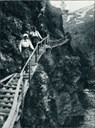
The history of Vassbygdi is to a large extent marked by the focus on the high farms, and in particular those located in the valley of Aurlandsdalen. These were known both by Norwegians and foreigners from the late 19th century when some of the deserted farms were used as accommodation for hikers. The farms were deserted when people migrated to America, most likely because of an increasing population, crop failures and periods of general decline. Before this the people of the high farms were used to living partly isolated lives in valleys hardly fit for travelling, where frequently the only alternative to getting contact with the outside world was by climbing steep crags and precipices by means of wooden ladders. Consequently, transporting animals took place across the mountains and not along the valleys. From the latter part of the 19th century dynamite was used at some of the steepest and most impassable places to make steep and narrow passages along the precipices, like those found at Sinjarheimgalden and Nesbøgalden.
The hike from Østerbø to the lake of Vassbygdevatnet
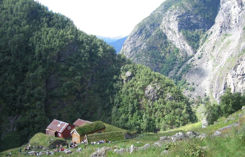
A popular hiking trail goes from the tourist cabin of Østerbø close to highway 50 down the valley of Aurlandsdalen and to Vassbygdevatnet. Along this trail we find many attractions and deserted farms. The high farms of Sinjarheim and Almen have been restored in recent years. Sinjarheim was the last farm in the valley to be deserted in 1922. The restoration work has been going on since 1988 and the houses are now in good condition and well worth a visit. Many visitors are fascinated by the unique location of the cottage of Almastova. It is built under the overhang of a gigantic boulder, protected from avalanches and rock falls.
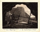
On this hike you can choose whether to go by way of the cairn of Bjørnestigvarden which is also known as a painting by Johannes Flintoe. He made this painting after hiking down the valley in 1819. Not far from the cairn there is a huge pothole filled with water, called Vetlehelvete (literally "Little Hell"). According to a legend, the water bubbles in Vetlahelvete if you throw a stone into the lake of "Svartatjødnet", 200-300 meters away.
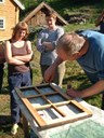
Idealism and communal spirit
The restoration of the farms in the valley of Aurlandsdalen is the result of an enormous effort of voluntary work and co-operation between various groups. "Aurlandsdalen Kulturlandskap" is a co-operative organization for all these groups, working with the restoration and maintenance of buildings, management of the cultural landscape and maintenance of the hiking trail. One of these groups is the "Dugnadsgruppa Aurlandsdalen", running the restoration project with the Society for the Preservation of Norwegian Ancient Monuments, as well as the "Aurland Naturverkstad". The co-operation project also includes landowners and craftsmen, the guide group called ANKA (Aurland Natur- og Kulturarv), Sogn Jord- og Hagebruksskule, the municipal authorities of Aurland, The Aurland and Lærdal Tourist Association, and The Norwegian Mountain Touring Association.