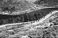
Difficult landing site in bad weather
The village of Kvalheim faces the ocean and its landing site has always proved difficult in bad weather. If bigger objects were to be moved, it had to be done by sea. The worst situations occurred in connection with funerals. Then people had to use rowboats past the bay of Kvalheimsvika, around "Hesten", along the Vågsvågfjord and up the strait of Ulvesundet to the church at Røysa. By land they preferred to use the path across the scree of Reinura, along the lake of Refvikvatnet to Hagen, and then on to Raudeberg. There was a desperate need for a better road to Raudeberg. When the local council of Selje in 1870 allocated 352 "spesiedaler" for a road between Kvalheim and Raudeberg, this was indeed a red-letter day. The road from Refvik to Raudeberg was completed in 1877. The road from Hagen to the outlying fences of the farms of "Indre" (inner) Kvalheim was completed in 1880, and the expenses were shared between the local council of Selje and the county council. In 1900, the total population of the Kvalheim farms was 188.
From sleigh/sled to carriage
Formerly the houses of Kvalheim were clustered at Haugen and Smibakken. As a result of the general parcelling of land which took place in 1890, the cluster of houses was split up and the houses got their present location. From now on the farmers replaced the sleighs/sleds with carriages. As soon as Kvalheim was connected by road to Raudeberg, the number of horses increased rapidly. Soon there were 25 horses in the village. Horse and carriage became more and more common, and later on more comfortable chaises were taken into use. It turned out that parts of the Kvalheim road were hard to negotiate, especially when spring thaw made the road almost impassable as the cartwheels got stuck in the mud.
The arrival of cars
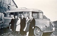
After the Skora road had been completed in 1923, it was possible to drive by car to Kvalheim. However, the last stretch of road up to the highest point made driving difficult. The present Kvalheim bends were built in 1932. The first cars were owned by Brunsvik, Loftnes and Sørland. Sørland started regular service to Kvalheim, first by open lorry, then with a covered back, and later on by bus. Henrik Myre took over this service in 1936 with a small lorry. Later he took over the transportation of milk that people at Kvalheim had previously carried out by horse and carriage. In the late 1940s, Henrik invested in a bus.
Maintenance
Each of the Kvalheim farms was responsible for putting gravel on their section of the road. The gravel was taken from small gravel pits that can still be seen along the road. Women also worked on the road. Annanias Myre was the first person to be employed to take care of the maintenance of this road. He started working before World War II, and he did a good job. He also paved the wheel tracks with stones, which eventually made it possible for cars to negotiate this road. The Kvalheim road was kept open for traffic throughout most of the winter. At first a wooden snowplough was used but this was later replaced by a stronger iron snowplough. The Kvalheim men had to help re-open the road in wintertime whenever snowdrifts closed the road. This voluntary system was kept until about 1960. During World War II, the Germans dug culverts under the road bends and placed explosives there. This was done after the Måløy raid to prevent the British from using this road in another raid. With bigger buses and lorries the road bends up from the Reinura scree had to be widened and this work was completed in 1965.
The happiness of owning a bike
Before World War II, young boys at Kvalheim started to buy bicycles. The bike was a convenient means of transport when they were preparing for their confirmation in the summer. It was also useful when they went shopping at Raudeberg or wanted to get in touch with young people from other villages. Having a bike meant perhaps more to people at that time than having a car today.
A dramatic event occurred on the Kvalheim road in 1961. A strong gust of wind threw the bus off the top bend of the road. Fortunately the bus hit a rock that smashed the roof of the bus, but it also stopped the bus from falling any further. If the accident had happened just before or after this spot, the outcome would certainly have been much more dramatic.
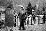
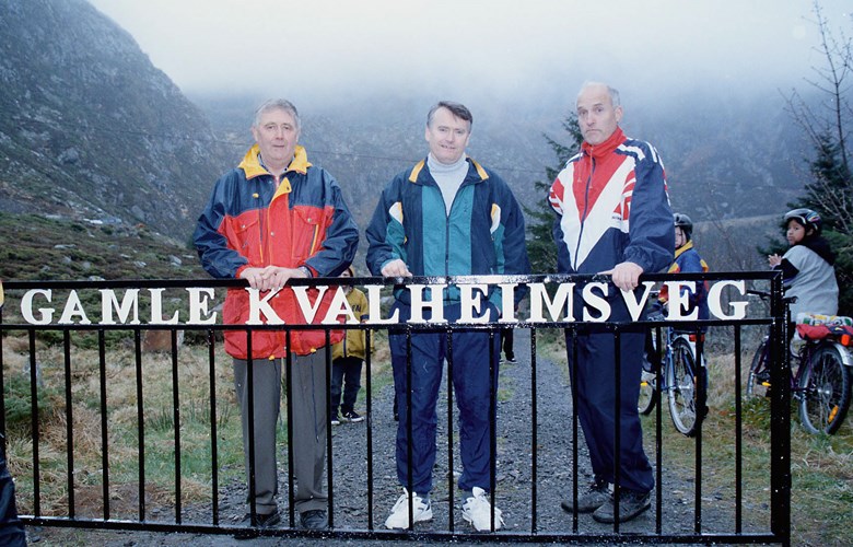
Friends of the Old Kvalheim Road
In the 1990s, the organization Friends of the Kvalheim Road was established by enthusiasts from Kvalheim, Refvik, Vedvik and Raudeberg. The aim was to repair the old road and turn it into a popular hiking and recreational trail. Hundreds of hours of voluntary work were put in, and people contributed with financial support and machines. Various fund-raising activities were organized, and their initiative was also supported by the Public Roads Administration and the local council. The old road has now become a popular hiking trail with a length of 2.4 kilometres. In April, 1998, the road was officially opened. "It is our hope that many people will use this road to explore this area, and we feel certain that the users will show the necessary respect for the vulnerable countryside," as the organization put it at the opening ceremony.