Plans for a rural road to Ålfoten
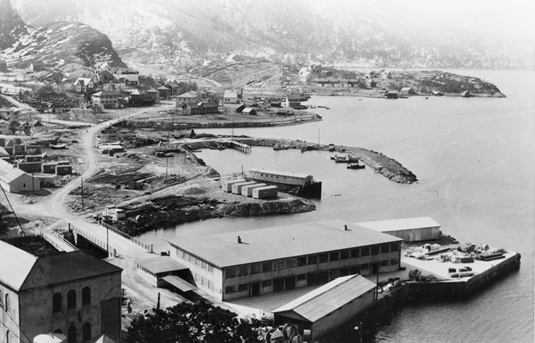
In 1900, Bremanger had only 1.2 kilometres of "cart road". In 1919, the municipal authorities demanded "reasonable road connections in Bremangerpollen and a main road from Ålfoten to Svelgen to be continued to Kjelkenes,..". In the road traffic plan of 1906, this project was not included, in spite of the fact that a hydroelectric development of the Svelgen watercourse would employ 500 men and lead to an annual zinc production of 30 000 tonnes. Bremanger was a farmer and fisherman community, where boats were the main means of transport. At that time, Svelgen had about 350 inhabitants, but the municipal centre was located at Kalvåg.

Power-intensive industry
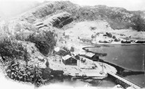
The development of the industry at Svelgen on the farms of Rise and Sande started up around 1914 with the establishment of "A/S Bremanger Kraftselskab" (Power company). In the first few years, the smelting plant produced zinc, but after the First World War, the demand for zinc was drastically reduced. In 1928, the company started with producing pig iron, and the name was now changed to "Bremanger Rujernsverk" (Pig iron plant). The Second World War put an end to this production. Only after 1955, the "A/S Bremanger Smelteverk", department under "Christiania Spigerverk", experienced a considerable growth with fresh capital and new owners.
The road between Svelgen and Florø
When the construction work started, there were few roads in and around Svelgen. All transport to and fro Svelgen was carried out by boat. It actually took more than 40 years before the building of roads started in earnest. In 1960, the road between Svelgen and Kjelkenes was opened for traffic. In 1964, Svelgen became the administrative centre in the municipality. The road between Kjelkenes and Haukå (25 kilometres) was then under construction. On 4 October 1965, the ferry service between Haukå and Bjørnset started up, and Svelgen was now connected by road to the outside world. Highway (RV) 614 gave a connection both to Florø and Førde.

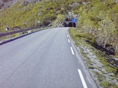
Two tunnels
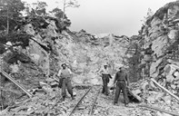
The road section Haukå-Myklebust was completed in the mid-1960s. The 12.6-kilometre-long road included two tunnels; Haukåtunnelen of 140 metres and Magnhildskartunnelen of 2875 metres. The tunnel construction through the gap at Magnhildskaret started in 1959, and was completed in 1966. At that time, this was the longest tunnel in the county, closely followed by Lotetunnelen of 2857 metres.
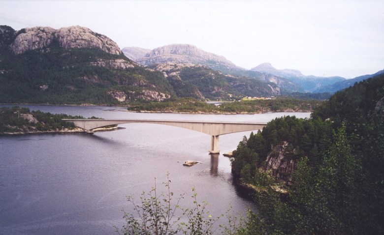
Going on strike for a bridge
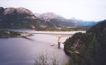
A road connection with a bridge across the Norddalsfjord was suggested as early as in 1940, but in 1957, politicians instead went in for a ferry service between Haukå and Bjørnset. It went so far that 700 people at Svelgen and Norddalsfjorden went on strike in 1980 to get a ferry-free connection. The county council gave priority to the bridge across the Norddalsfjord over the bridge across the Dalsfjord in the road plan for 1978-81, but this was turned down by the Storting. The Norddalsfjord Bridge was not included until the next road plan.
The Norddalsfjord Bridge
A ferry-free southward connection came in 1987 with the opening of the Norddalsfjord Bridge. This new connection gave 3000 people from the mainland part of Bremanger and the Norddalsfjord area a ferry-free connection to the outside world. An important reason for the increased road construction efforts was the strong economic growth in industry. In the 1970s, the smelting plant experienced an incredible growth. More than 500 persons were employed at the plant, and in 1980, Svelgen had 1500 inhabitants.
Northward ferry connection: Stårheim-Isane
In 1920, the municipal council of Bremanger sent an application for a road between Svelgen and Ålfoten, but it was turned down. The roadwork was started from the north in the 1960s. In 1971, the 1733-metre-long Viktunnel was finished and in the autumn of 1972, the road between Svelgen and Isane was opened for traffic. With this road and the ferry connection between Isane and Stårheim across the Nordfjord, Svelgen was now connected to highway RV 15 west to Måløy and eastward out of the county.