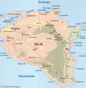
Hiking around the island of Selja
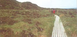
There is a track all the way around the island. The easiest and most used part of the track goes on the north side of the island with a nice view of the Stadfjella mountains to the north and the open sea of Stadhavet to the west. It takes about half an hour to walk in a flat and boggy terrain to the monastery on the western side. This part of the track is the oldest one, and in the last few years it has been improved considerably with wooden bridges and wooden boards across the wettest sections. The track on the south side is not used so much. The terrain is more demanding, and it will take about an hour to walk from the monastery to Bø along this path. The countryside is more dramatic on the south side of the island, with a commanding view of the Røysetfjord, the island of Silda and the ocean itself.


The track on the north side
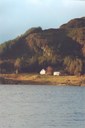
The track between Bø and the monastery along the northern side of the island is very old. From Bø, where the parish church was located until 1654, the hiker can follow in the footsteps of pilgrims and other travellers in the Middle Ages. The bogs on the north side of the island were cultivated then. In more recent times peat has been cut there. Halfway between Bø and the monastery is the hill of Buskhaugen, or Bispehaugen (the Bishop's hill) as it is also called. There we find stone-wall remnants of a building that has not yet been studied or dated. The bay of Helmavika, (actually Heilag-mannavika, that is, the holy man's bay) is located closer to the monastery. This is said to be the place where Sunniva and her followers, according to legend, first came ashore.
The track on the south side
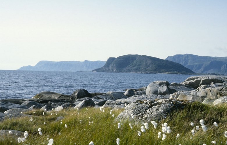
If you follow the track from the monastery area along the south side towards Bø, you will get to an overhanging rock called Dunhelleren. The rock lies down by the seaside with several openings. The name probably has to do with the roar of the waves breaking against the rock. Along this track you may also get a glimpse of the wild goats on the island. It is not unusual either to catch sight of the white-tailed sea eagle in this area. The track crosses some small hills and sometimes it turns down to the seaside.
Facing the south and sheltered by the mountain lies Heimen (literally, the home). Here the monks are said to have cultivated hop and perhaps other thermophilic plants. At Heimen and in the gap of Heimsskaret burial mounds and remnants of an old house have been found. The old house may have been a longhouse from the Iron Age. The hill of Ilshaugen (literally, fire hill) on the south-east side of Selja was formerly used as a bonfire cairn from the times when ships were conscripted for naval service. The bonfire cairn was last used in 1810 during the Napoleonic wars.
On the east side of the island the track passes the farm where the painter Bernt Tunold (1877-1946) was born and raised. From this place he got the motifs for many of his paintings.

Sigrid Undset was not allowed to buy a lot
In 1926, Sigrid Undset tried to buy a lot at Bø, but did not succeed. She was so preoccupied with Selja and Saint Sunniva that she in 1926, the same year she was awarded the Nobel prize for literature, completed a manuscript, The holy Sunniva, with the artist Gøsta af Geijerstam as an illustrator. The book was published in Norwegian only in 2000!