Storting decision led to the founding of a city
In 1858, the Council of State appointed a commission with a mandate to discuss the location of a city in the region of Sunnfjord or Nordfjord. This had to do with a desire to increase the trade of fish and fish products, and there was also dissatisfaction with the trade in Bergen. Florø was chosen as it had a central location along the inner shipping lane on the coast. In addition, Florø was located close to the economically important spring herring fisheries. On 16 May 1860, the Storting passed "a law concerning the founding of a city at Florøen in the Kinn parish." The location of the new city was between the two farms of Øvre and Nedre (Upper and Lower) Florø with a population of hardly more than 50 persons.
On the road connection in the commission report
The commission that was appointed to discuss the city issue, expressed as early as 1858 that: "Florøen has such a location that, if in time this is considered necessary, a road can be built from Førde and from Hyen in Nordfjord, where a more than 20-kilometre-long public road has already been completed. The city will thus become linked overland with the inner districts". Close to 100 years would pass until these ideas of the commission could be realized.

Road demands from the 1890s
The first person to start working for a road connection between Florø and Eikefjord was F. T. Lorenzen, mayor (1888-90) and district doctor in Kinn (1880-90). The city council of Florø asked the mayor in 1891 to turn to "the county governor with a request to get the road surveyed, at least as far as to Brandsøysundet". Førde, Gloppen and Kinn all supported this request. They demanded a survey of a road between Florø-Eikefjord-Førde and Hyen. The issue was brought up by the municipality both in 1892 and in 1893, and it was pointed out that the road connection would be of vital importance to the outlying districts. At the same time, people were also discussing a road between Førde and Naustdal.
Many demands, but no action
In 1906, the city council appointed a committee that would present the road issue to the county council. Very little came out of this initiative. In the first road plan of 1907, the Florø-Brandsøy road was not given any priority until 1932, and then as a rural road. The road further on to Eikefjord was categorized as a main road, but would not be included in the 30-year period. In the traffic plan of 1919, it was written that Florø "suffers under the lack of overland road connection with the city's surrounding villages, and that this was indeed a unique situation".

To the capital to ask for money
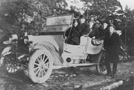
In 1920, the city council once more brought up the demand to build an "automobile road" from Florø to Eikefjord and further on to Naustdal, Hyen and Sandane. Kinn and Florø wanted to allocate 7 % to the Florø-Brandsøy connection. The Florø mayor went to Oslo to apply for means through employment relief.
Employment relief and threat of strike.
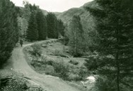
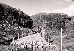
In 1922, the roadwork was started with employment relief means, on the condition that the district covered one tenth of the cost. The cost of the whole project was estimated at 353,000 kroner. The road between Florø and Brandsøysundet (6.1 kilometres) was completed in 1937 at a cost of 330,660 kroner. The work was carried out not without conflicts. It was not very well received when the poverty commission in 1934 refused to pay the road workers a small sum in advance, which they had been promised. The workers threatened to go on strike if they did not get the advance payment. The times were hard for many people. The board of aldermen did a turnaround and the poverty commission was told "that workers with such big families that they cannot cope with the advance payment, will get an appropriate supplementary payment per week in addition to the advance paid out. The piecework rate was 0.50 kroner per hour with a family supplement ranging from 0.03 to 0.12 per hour.
Road by way of Vevring or across Ramsdalsheia
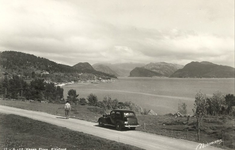
The road demand was brought up on a number of occasions both by the municipalities of Florø and by Førde, supported by all other involved municipalities, but the whole time other road projects were given priority. The first allocation to the Førde-Florø connection was given in 1911 to be used on the road Førde-Naustdal. The last allocation came only in 1937/38. There was an increased interest in the road project between Florø and Førde, especially since it was decided in 1930 to build a county hospital in Florø. However, doubts were raised in the choice of road line, either straight across from Naustdal to the valley of Ramsdalen or by way of Vevring along the fjord. The latter was preferred, also by the Storting. However, it was the line across Ramsdalsheia that was eventually built.
Germans speeded up the road work
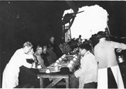
In 1937, the work with the road from Brandsøy to Eikefjord was continued. When the war broke out in 1940, two kilometres of road had been completed. At the same time, the financing of the road between Naustdal and Storebru had been secured. Iy was important for the Germans to build a road to Førde for strategic reasons. Then they would have an opportunity to retreat in the case of an allied attack on the city. The Public Road Administration was in charge of the work which was continued in great strength. In 1942, they started work on a number of road sections simultaneously. Russian prisoners of war were also used for a while.

Question of sabotage
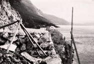
For long sections of the road, there were stone walls straight down to the fjord. Once when they were making a stone wall by hand, the wall foundation collapsed, and the whole stone wall - 50 metres long - fell into the fjord. This incident was investigated by the Germans who suspected sabotage, but the investigation revealed that there was a natural explanation. The new wall foundation was secured by blasting into the rock.
The co-operation between the German occupation forces and the Public Road Administration was far from smooth. Sectional engineer for the road section in Sunnfjord, Erling Skåre, was in charge of the road project. In July 1944, he was arrested by the Germans because he had expressed himself negatively about the Norwegian political party "Nasjonal Samling" (National Unity). The district chief road administrator Alf Torp threatened to stop the whole road project unless Skåre was set free.
Across the Ramsdalsheia to Naustdal
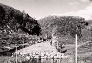
In 1944, the road to Eikefjord was completed. On 15 July 1944, the bus company Firda Billag started regular bus services between Florø and Eikefjord. The Sunde tunnel work had taken much time. The majority of the workforce was now used on the further roadwork into the valley towards Ramsdalsheia. In 1945, a total of 240 men were now employed on various sections from Storebru to the Indrekvam bridge in Naustdal. In the spring of 1945, it was possible to drive between Florø and Førde on highway #585. Some road sections were rather bad. The final completion and official opening of the road took place only in 1952.