From Beitelen to Dyrdal
At Nærnes, on the western side, and Beitelen, on the eastern side, the Nærøyfjord separates from the Aurlandsfjord. The first section of the fjord is the widest with vertical mountainsides and cascading waterfalls. One of these is the waterfall of Lægdafossen in the river called Sagelvi that we can see when we pass the point of Krossnes. On the opposite side the river of Kappadalsgrovi tumbles down into the bay of Kappadalsviki.
There are no farms until we get to Arnehus and Dyrdal on the west side of the fjord. In 1737, Arnehus was granted the privilege of running an inn and a general store, "highly necessary for travellers". Arnehus was also a permanent court site for the Nærøy "skipreide" (the smallest administrative unit) which comprised the "sokns" (sub-parishes)of Underdal (with the Nærøyfjord and the valley of Nærøydalen) and Oppheim (Vossestrand).
High up in the valley, some distance up and to the west of Dyrdal is the farm of Drægo. For centuries there has been a connection across the mountains between Dyrdal and Fresvik on the Sognefjord. These mountains have been one of the best hunting grounds for reindeer and deer in Aurland. About 50 bird species and 20 species of mammals have been registered along the fjord. In the last few decades there have been many seals in the fjord, and in the 1990s, more than 100 seals were counted.

Styvi and the "Bleiklindi" (the pale linden tree)
Straight across the fjord from Dyrdal there is a place called "Solaløysa", meaning a place where the sun never shines.
Further into the fjord opposite Dyrdal is the farm called Styvi. From Styvi a wide track leads to Bleiklindi. This track used to be part of the royal postal road between Bergen and Christiania (Oslo). The post was carried on foot from Bergen by way of Voss, Stalheim and Gudvangen. In the summer months the post was transported by boat from Gudvangen to Lærdal, but when ice covered the fjord in wintertime, the track from Bleiklindi to Styvi was used. Off Styvi the fjord is both wider and deeper, and the fjord does not freeze over so easily there. From Styvi the post was transported by means of rowboat all the way to Lærdal.
"Bleiklindi" is a protected cultural tree and is a botanical rarity. The leafing is late with a yellow-green colour in spring. When other deciduous trees turn yellow in the autumn, the leaves on the pale linden tree turn into a darker green.
Further west of Styvi, the fjord narrows considerably, and the narrowest part is only 250 metres across. Nevertheless, big cruise liners frequently sail all the way in to the head of the fjord at Gudvangen. From Styvi and past Bakka the fjord is narrow and shallow. The fjord often freezes over in cold spells with little wind.
Landscape protection area
Down by the fjord, along the road between Styvi and Bleiklindi, is a place called Holmo. The Styvi farm used to have a "spring farm" there until after the Second World War. At Holmo there is a big protected burial mound from the late Iron Age. The diameter of the burial mound is 15 metres, with a height of 2 metres, and this is the biggest of its kind in the municipality of Aurland.
The Styvi-Holmo landscape protection area was established in 1991 to protect a part of a scenic and interesting natural and cultural landscape from fjord to mountain with geological deposits and cultural monuments. On 8 November 2002, the Nærøyfjord landscape protection area was established, an extension of the previous landscape protection area by the fjord. The area also comprises one of the most spectacular fjord areas in the world. It represents a continuous and highly diverse landscape, stretching from the fjord up to mountain peaks 1700 metres above sea level. The Fresvikbre glacier lies inside this area. In 2005, the fjord landscape around the whole Nærøyfjord was inscribed on the prestigious UNESCO World Heritage List of the world's most unique natural and cultural monument sites worthy of preservation.
Tufto and Bakka
Straight across on the other side of the fjord from Holmo lies the farm Tufto. A little further to the west is the hamlet of Bakka. At Bakka we find the "sokn" (sub-parish) church for the Nærøy "sokn" in the Aurland parish. Nærøy became a separate "sokn" in 1859 when the Bakka church was consecrated. Until that year, the people in the valley of Nærøydalen and along the Nærøyfjord had belonged to the Undredal "sokn".
From Tufto and Bakka the county road 241 leads to Gudvangen. This road was once built as a section of the royal postal road between Bergen and Christiania (Oslo). In 1848, the issue of building a road between Gudvangen and Bakka was brought up in the county council for the very first time. However, no allocations were given until 1852, and then in the form of a district grant. This road is extremely exposed to avalanches, and the road has frequently been closed for traffic. In 1997, this road was included in the Public Roads Administration's plan for avalanche protection. On 28 September 2001, the 1754-metre-long Bakka tunnel was opened for traffic. It is a single-lane tunnel with passing places at every 250 metres.

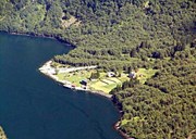
The boat stop of Gudvangen
At the head of the fjord we find the farm Ramsøy and the fjord village of Gudvangen. Ramsøy is located east of the river at the mouth of the Gudvanga tunnel. Now we find a petrol station and a general store there after the road line was changed.
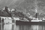
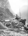
To the west of the Nærøydalselvi river is the boat stop of Gudvangen. From the 17th century, the royal postal road went from Bergen by way of Voss, Gudvangen, Lærdal and across the mountains of Filefjell, down the valley of Valdres and onwards to Christiania (Oslo). Since that time, Gudvangen has been an important hub for the east-west communication in the south of Norway. Still, it took close to four years from the time the local steamship company "Fylkesbaatane" established the first regular steamship services on the Sognefjord until Gudvangen was included as a boat stop. Towards the end of the 19th century, the tourist traffic had increased so much that the steamship company in 1886 could no longer provide satisfactory services between Lærdal and Gudvangen. The passenger boats used were too small and became so crowded that people started to complain. The railway line between Bergen and Voss was opened for traffic in 1883, which was a contributory factor to the increased traffic by way of Gudvangen. In 1868, 795 passengers travelling by boat from Gudvangen were registered. In 1904, this had increased to 4100 passengers, and in 1912, the figure is said to have been about 20 000.
Ferry services
In 1927, the road section between Gudvangen and the boundary to the county of Hordaland was classified as a national highway.
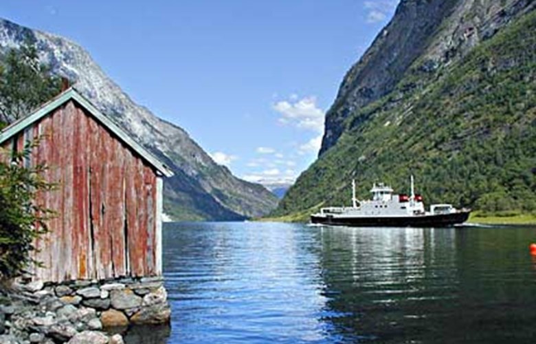
In 1934, the "Fylkesbaatane" steamship company established the first car ferry service from Gudvangen, a rather special service which included changing ferries mid-fjord at Solsnes. In 1939, however, the ferry connection between Gudvangen and Lærdal started in earnest, a ferry connection that was extremely important until the long Lærdalstunnel between Lærdal and Aurland was opened in November 2000. The ferry connection was then discontinued on a year-round basis, and at present the ferry only operates between 15 May and 30 September. The Nærøyfjord is an area of outstanding natural beauty and cultural monuments, and for this reason it is important to keep the boat connections on the fjord.
The communication situation for the isolated farms and hamlets along the fjord became significantly worse when the year-round ferry service was discontinued, but in the summer months the service is just as it used to be.